mount panay gallery

Mount Panay, the highest point of Calumpang peninsula (often, and imprecisely, referred to as Anilao) is a rewarding place for hiking. If you start early in the morning you can make it to the top at 580 meters above sea-level from Barangay Ligaya and be back for lunch. Mount Panay has 360 degrees views of a good part of Batangas Province, and you can also see Mindoro, Lubang Island, and Tagaytay.

Anilao and Tamarind Beach

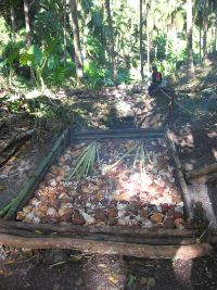
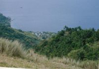
The generally steep hillside from Barangay Ligaya to the top of Calumpan Peninsula, is mosly covered with thich tropical greenery. Big leaves like these are sometimes used as umbrellas by the locals. Improvised kilns like this one is used to make copra. The southmost part of Barangay Ligaya as seen from Mount Panay. The top of Calumpan Peninsula is flat and grassy. Mount Panay can be seen in the clouds behind. Maricaban Island and Sombrero can be seen to the southwest, and behind that in the mist, Mindoro. The eastern tip of Maricaban Island across the Maricaban Channel. The channel connects Balayan Bay with the smaller Batangas Bay. The small island in the mist behind Maricaban is Bonito Island.

www.ligaya.net Jens Hintze Holm jens@ligaya.net